
Whole of Britain & British Isles
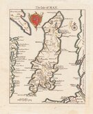
Isle of Man
( Page 1 of 2 )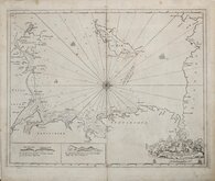
Greenville Collins Irish Sea 1688 [c.1693]
Thomas Read 1743 [1753]
Thomas Kitchin 1763
Joseph Ellis 1765 [1773]
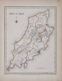
Roger Creighton 1831
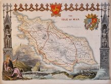
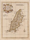
Thomas Moule 1843
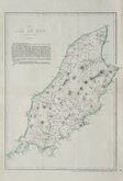
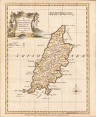
Edward Weller 1863 [1867]
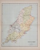
Francis Weller 1891


20x27 cm
HIGHLY DECORATIVE VICTORIAN MAP.
THE ISLE OF MAN.
LONDON PUBLISHED BY G. VIRTUE 26 IVY LANE, JUNE 1, 1843.
This series of decorative steel-plate engraved maps are commonly known by the author of the work in which they first appeared; Moule's English Counties Delineated. First issued from May 1830 in a series of parts, the first complete edition was published by George Virtue in 1837. Several editions followed until 1839 and the plates were then used by George Virtue and his son James Sprent Virtue in A Complete and Universal Dictionary of the English Language by the Rev. James Barclay until 1857. The engraving of the plates was shared between James Bingley, William Schmollinger and John Dower. The plates underwent a number of changes, including the unexplained interchanging of engraver's names in the early issues, and were frequently updated to reflect the rapidly developing railway network.
Thomas Moule was born in Marylebone on January 14th 1784. He was a bookseller in Grosvenor Square between 1816 and 1822. He was inspector of 'blind letters' in the General Post Office for forty years and also held the office of Chamber-keeper of the Lord Chamberlain's department which gave him an official residence in the stable yard, St. James a lace where he spent the later years of his life and died on January 14th 1851. During his life Thomas Moule wrote a number of books on heraldry and antiquities, these interests being reflected in the decorative neo-gothic elements and coats of arms that surround his maps. It was this return to the decorative armorial cartography of the 17th and 18th centuries that contributed to the commercial success of his maps that remain popular to this day.
The engraver of this HIsle of Man plate, James Bingley (1796-1869), was born at Leicester on 6th May 1796. He married Ann Elizabeth Hardy from Chelsea 19th November 1820 at St. Martin in the fields. Engraver, copperplate printer, mapmaker and coloured-paper manufacturer, he was in a publishing partnership with Francis Roxburgh and William Schmollinger in 1833 which led to Bingley being imprisoned for debt. On the 1841 census he is recorded as a copperplate printer living with his wife in Shoreditch and was possibly connected with the firm Batho & Bingley, banknote engravers and printers at Lombard Street. His death, at the age of 73 was registered at Holborn in the final quarter of 1869.
Some toning at left and right margins but still a fine example from the 1843 edition of Barclay’s Dictionary in later hand colour. North is to the right.
SPECIAL OFFER MOUNT OPTION ON THIS ITEM AT CHECKOUT FOR UK DELIVERY.
Quick Links


Folding Maps

Lancashire Maps
×