
Folding Maps
Isle of Man
( Page 1 of 2 )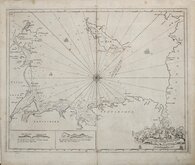
Greenville Collins Irish Sea 1688 [c.1693]
Thomas Read 1743 [1753]
Thomas Kitchin 1763
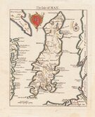
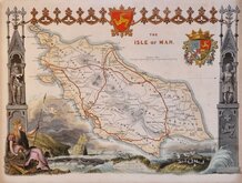
Joseph Ellis 1765 [1773]
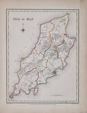
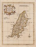
Roger Creighton 1831
Thomas Moule 1843
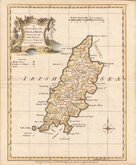
Edward Weller 1863 [1867]
Francis Weller 1891


20x25 cm
DECORATIVE PASTORAL TITLE CARTOUCHE
A Modern MAP of the ISLE of MAN, Drawn from the latest Surveys: Corrected & Improved |by the best Authorities.
Printed for Robt. Sayer in Fleet Street & Carington Bowles in St. Pauls Church yard.
First published in The New English Atlas… in 1765, the atlas became a considerable success with many editions, under the title Ellis's English Atlas, being published over a period of thirty years from the offices of Robert Sayer and Carington Bowles. Most of the maps were copied from those by Thomas Kitchin in a rival publication of similar pocket size by Robert Dodsley England Illustrated first published in 1763 but which did not achieve the same success.
Good clean hand coloured example from the 1773 edition of Ellis's English Atlas.
Quick Links


Lancashire Maps

Whole of Britain & British Isles
×