
Europe
Historical Maps
( Page 1 of 10 )
Saxon Heptarchy Robert Morden 1695

Roman Britain Robert Morden 1695
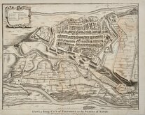
Cuneo Piedmont Savoy 1727
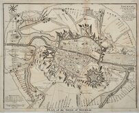
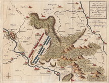
Siege of Tournai 1727
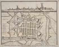
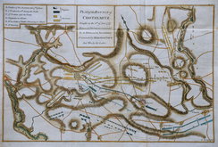
Nieuwpoort Belgium 1727
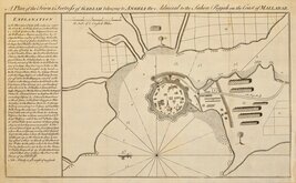
Vijaydurg Fort 1756
Battle of Hastenbeck 1757
Battle of Kolin 1757

£35 Saxon Heptarchy Robert Morden
Ref: 6473
Add to
basket
Thanks,Your Product Has Been Added To Basket

30x38 cm
BRITANNIA Saxonica.
Iohn Sturt sculp.
England and Wales as it was divided during the Saxon Heptarchy.
Produced by Robert Morden (fl.1669-1703) for publication in Edmund Gibson's translation of William Camden's Britannia, London, Awnsham and John Churchill and Abel Swale, 1695.
The work is best known for the editions that included county maps of which Morden's, in 1695, were the first. Also included were two historical maps, this map of England and Wales under the Saxons, and one of Britain during the Roman occupation.
The work was republished in 1722, 1730, 1753 and 1772. There were a number of minor alterations to most plates during the early editions. They were substantially updated for the 1722 edition with changes to place name spellings and the plates were re-worked due to wear caused by the printing process, for the 1753 edition.
Robert Morden (fl. 1669-1703) mapmaker, mapseller, globemaker, engraver and publisher, is best known for his county maps published in Camden’s Britannia and little is known of his early life. His output was considerable, producing maps and other works in association with many other well known mapmakers and publishers including John Overton, Philip Lea, William Morgan and Christopher Browne. He was a frequent partner of William Berry from the Wakefield area of Yorkshire who was apprenticed to Joseph Moxon, it is most probable that Morden was also apprenticed to Moxon and, given that the Morden name and variants of it are common in Wakefield, he may also come from that area. Morden is recorded as having the polymath Robert Hooke and diarist Samuel Pepys among his customers and associates. He was a member of the Weavers company and churchwarden of his parish church, St. Christopher-le-Stocks, 1679-1680. He and his wife Mary baptised at least seven children at the same church and he was buried with his wife “in ye north ile” on 25th August 1703. Morden did not receive royal appointments granted to less able contemporaries, and he described himself as having “lain latent under the horizon of unknown obscurity and irresistible poverty” and hoped for “better rewards” in the next world.
The engraver, John Sturt (1657-1730) draughtsman, engraver, writing-master and teacher of shorthand and arithmetic. Born London 6 April 1657. From about 1697 he kept a drawing school in St. Paul's Churchyard. He engraved bank notes for the Bank of England from 1702-1720. He was noted for his calligraphy, initial letters, decorative headpieces, and miniature work and was described by John Senex (1678-1740), geographer to Queen Anne, as one of the ablest hands in England.
Some wrinkling to the paper at the centrefold otherwise a good example in neat later hand colour.
Quick Links


Mediterranean

Road Maps
×