
Europe
Historical Maps
( Page 1 of 10 )
Saxon Heptarchy Robert Morden 1695

Roman Britain Robert Morden 1695
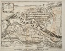
Cuneo Piedmont Savoy 1727
Siege of Tournai 1727
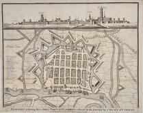
Nieuwpoort Belgium 1727
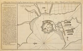
Vijaydurg Fort 1756
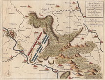
Battle of Hastenbeck 1757
Battle of Kolin 1757


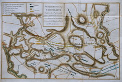
48x39 cm
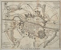
TOURNAY A Strong City and Castle in the Earldom of FLANDERS, taken by the CONFEDERATES July 7.1709. and left as a Barrier Town to the Dutch by the Treaty of UTRECHT.
PLAN of the SIEGE of TOURNAY.
For M.r Tindal's Continuation of M.r Rapin's History of England.
I. Basire sculp.
Engraved by Isaac Basire (1704-1768) for Reverend Nicholas Tindal's continuation of The History of England by Rapin de Thoyras published from 1727.
Showing the plan of the city of Tournai, Belgium, then part of France, it's citadel and fortifications as beseiged by the Allies led by the British Duke of Marlborough during the War of the Spanish Succession between 28th June and 3rd September 1709.
Folds as issued, with four archival repairs verso to short splits at folds, one, at top left margin slightly parted and with manuscript retouching to border lines. Occasional light browning. Small and uneven bottom margin close to imprint.
Quick Links


Road Maps

Mediterranean
×