
Essex Maps
Hertfordshire Maps
( Page 8 of 11 )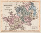
Sidney Hall 1830 [1833]
John Heywood 1830 [1858]
Roger Creighton 1831
Robert Kearsley Dawson 1831
Roger Creighton 1831
Roger Creighton 1831 [c.1833]
Roger Creighton 1831 [c.1840]
Roger Creighton 1831 [c.1848]


23x16 cm
FULL ORIGINAL HAND COLOUR
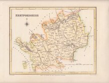
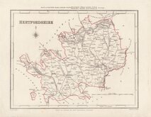
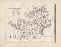
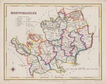
HERTFORDSHIRE.
ENGRAVED BY SID.Y HALL.
London, Published by Chapman & Hall, No.186 Strand,1833.
Engraved by Sidney Hall (fl.1818-1860), this series of maps first appeared in Gorton's Topographical Dictionary issued in parts over a three year period from 1830, the complete work not published again after 1833. The maps were then issued in A New British Atlas…, Sidney Hall's British Atlas…, A Travelling County Atlas… and other variations on the title, published by Chapman and Hall from 1834 until c.1888. It's popularity due in part to regular updates to the plates to include the latest railway developments. The maps were intaglio printed until c.1858 and then by lithographic transfer. The engraver, Sidney Hall is no relation to the joint founder William Hall (with Edward Chapman) of the publishing firm Chapman and Hall, well known as publishers of the works of Charles Dickens.
This intaglio printed example, with Chapman & Hall’s address corrected from 168 to 186 Strand, was published in 1833 & 1834.
Very good example in original hand colour.
Ref. Hodson Printed Maps of Hertfordshire. 92 (ii)
Quick Links


Middlesex Maps

Hertfordshire Prints
×