
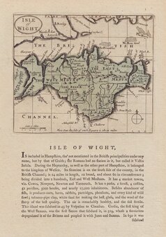
Isle of Wight
Hampshire Maps
( Page 1 of 3 )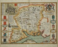
John Speed 1611
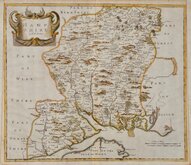
Robert Morden 1695
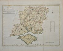
Emanuel Bowen 1720
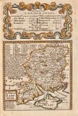
Thomas Read 1744 [1769]
John Haywood 1791
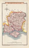
George Cole 1810
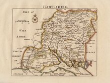
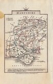
Sidney Hall 1820 [1834]
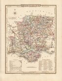
George & John Cary 1822


23x17 cm
WOOD ENGRAVING BY A WOMAN DURING THE REIGN OF WILLIAM IV
No. L.] GUIDE TO KNOWLEDGE. PRICE ONE PENNY.
HAMPSHIRE
Engraved by S.Hall Bury Street Bloomsbury.
Published by W.Edwards, Ave Maria Lane.
Woodblock engraving published in The Guide to Knowledge...by W.Pinnock...W. Edwards London 1833-34.
William Pinnock (1782-1843), born in Alton, Hampshire became a schoolmaster. In 1817 he moved to London and, in partnership with Samuel Maunder, began the publication of cheap educational works. The Guide to Knowledge was a publication issued in weekly parts between 1833 and 1834 and containing maps printed from the woodblock with the incised lines appearing white on a black ground. Some counties were published with revised borders by Groombridge Shepherd & Sutton in 1838.
The technique proved unpopular for topographical maps and was not used again, the county maps were issued later in a more traditional format by lithographic transfer in rare issues of Johnson's Atlas of England in 1847 & 1863.
Often attributed to Sidney Hall (1788?-1831), but the engraver was almost certainly Selina Hall, née Price (1708?-1853), wife of the well known engraver. Selina continued his engraving business after his death and, as a highly skilled engraver whose work is almost indistinguishable from her husband's, was very likely also responsible for some of his output in his later years. Selina signed her work "S.Hall" while Sidney usually signed his maps "Sidy. Hall".
This example of the Hampshire map has some repairs verso to the top margin including a repair to a tear extending 3cm into the map but is difficult to detect on the map face.
Quick Links

Wiltshire Maps

Berkshire Maps
×