
Road Maps
Cambridgeshire Maps
( Page 4 of 4 )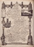
Thomas Moule 1832
Thomas Moule 1832 [1845]
Robert Scott 1833
Joshua Archer 1842 [1845]
Joshua Archer 1842 [1848]
John Dower 1863 [1867]


20x27 cm
RARE PRE-ATLAS ISSUE IN PAPER COVERS WITH 14 PAGES OF TEXT.
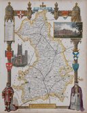
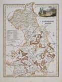
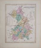
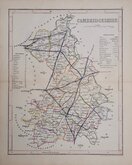
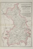
Cambridgeshire.
Engraved for MOUL’S ENGLISH COUNTIES, by W. Schmollinger.
This series of decorative steel-plate engraved maps are commonly known by the author of the work in which they first appeared; Moule's English Counties Delineated. First issued from May 1830 in a series of parts, the first complete edition was published by George Virtue in 1837. Several editions followed until 1839 and the plates were then used by George Virtue and his son James Sprent Virtue in A Complete and Universal Dictionary of the English Language by the Rev. James Barclay until 1857. The engraving of the plates was shared between James Bingley, W. Schmollinger and John Dower. The plates underwent a number of changes including the unexplained interchanging of engraver's names in the early issues and were frequently updated to reflect the rapidly developing railway network.
Thomas Moule was born in Marylebone on January 14th 1784. He was a bookseller in Grosvenor Square between 1816 and 1822. He was inspector of 'blind letters' in the General Post Office for forty years and also held the office of Chamber-keeper of the Lord Chamberlain's department which gave him an official residence in the stable yard, St. James a lace where he spent the later years of his life and died on January 14th 1851. During his life Thomas Moule wrote a number of books on heraldry and antiquities, these interests being reflected in the decorative neo-gothic elements and coats of arms that surround his maps. It was this return to the decorative armorial cartography of the 17th and 18th centuries that contributed to the commercial success of his maps that remain popular to this day.
This map is the parts issue (No XXVI) published in 1832 by Virtue, Simpkin & Marshall and Jennings & Chaplin before the complete atlas and remains stitched into the printed paper covers with 14 pages of description of the county. The paper covers are spotted, a little frayed and splitting at the spine. The map is generally clean with good margins though with a light water-stain bottom right corner and a little browning top right corner.
Examples from this issue are very rare today.
Quick Links


Town Plans
Cambridgeshire Prints
×