
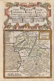
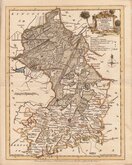
Road Maps
Cambridgeshire Maps
( Page 1 of 4 )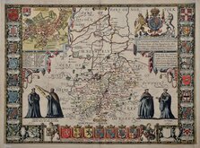
John Speed 1611
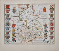
Jan Blaeu 1645
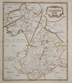
Robert Morden 1696 [1753]
Emanuel Bowen 1720
Thomas Read 1743 [1769]

Thomas Kitchin 1750 [1786]
George Bickham 1752
Joseph Ellis 1765


19x26 cm
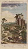
STEEL ENGRAVING. VIGNETTE OF KINGS COLLEGE CHAPEL.
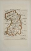
CAMBRIDGE SHIRE.
Pubd. by Archd. Fullarton & Co. Glasgow.
Steel engraving by Robert Scott first published in Bell's New and Comprehensive Gazetteer in 1833. The text for the gazetteer was largely copied from Lewis' Topographical Dictionary of 1831 and in 1839 Lewis obtained an injunction against Bell for plagiarism and the work was withdrawn. Archibald Fullarton, the publisher ofBell's Gazetteer republished the maps with new text in The Parliamentary Gazetteer from 1840 until 1849. The engraving work was shared between Gray & Son, James Neele and Robert Scott with most maps copied from those by Sidney Hall in an earlier topographical dictionary, John Gorton'sTopographical Dictionary of Great Britain and Ireland published in 1831.
The vignette of Kings College Chapel, Library & Senate House bears the signature of Robert Scott and the map has the compass rose design used by Scott.
Horizontal folds as issued. A good hand coloured example.
Quick Links

Cambridgeshire Prints

Town Plans
×