
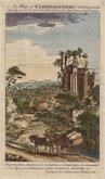
Cambridgeshire Prints
Cambridgeshire Maps
( Page 1 of 4 )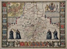
John Speed 1611
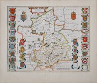
Jan Blaeu 1645
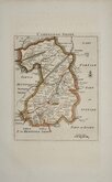
Robert Morden 1696 [1753]
Emanuel Bowen 1720
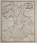
Thomas Read 1743 [1769]

Thomas Kitchin 1750 [1786]
George Bickham 1752
Joseph Ellis 1765


43x31 cm
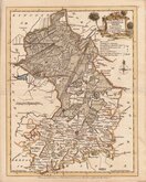
DISPATCH MAP CASSELL EDITION.
CAMBRIDGESHIRE.
BY JOHN DOWER. F.R.G.S.
LONDON, PUBLISHED BY CASSELL, PETTER & GALPIN. LA BELLE SAUVAGE YARD, LUDGATE HILL, E.C.
Lithograph printed map engraved by John Dower first published in The Weekly Dispatch between 1856 and 1862. The maps were also published as loose sheets and, when the series was complete, in The Dispatch Atlas from 1863. The publishers Cassell Petter and Galpin acquired the plates publishing them as loose sheets from 1864 and in Cassell's Illustrated family paper and Cassell's British Atlas in 1867. By 1869, the firm of G. W. Bacon had acquired the plates and published them in a number of titles for over forty years.
John James Dower (1825-1901) Map draughtsman, engraver, lithographer, glyphographer and printer. He was born in London 1st June 1825, the son and successor of John Crane Dower (1791?-1847) and was recorded as an engraver at age fifteen. He was elected to the Royal Geographical Society 9th Jan 1854. He is recorded as a geographer on the 1871 Census living with his wife and three children, as a wood engraver on the 1881 Census now with his wife, two daughters, and two small grandchildren. In 1891, described as a map engraver and draughtsman he was now a widower lodging in Wansted. His death was recorded at Hackney in the first quarter of 1901.
A good hand coloured example from the fourth lithographic transfer, with statistical information in typeset text transferred to the lithographic plate, published in Cassell's British Atlas...London Cassell, Petter & Galpin 1867.
Quick Links

Road Maps

Town Plans
×