
Berkshire Maps
Buckinghamshire Maps
( Page 1 of 4 )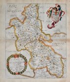
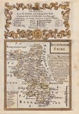
Richard Blome 1673
John Seller 1694 [1784]
Robert Morden 1695
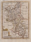
Robert Morden 1695 [1753]
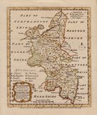
Robert Morden 1701 [c.1708]
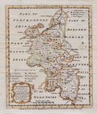
Emanuel Bowen 1720
Emanuel Bowen 1758
Emanuel Bowen 1758


34x42 cm
FIRST MAP OF THE COUNTY TO SHOW LONGITUDE FROM LONDON
BUCKINGHAM SHIRE By Robert Morden
Sold by Abele Swale Awnsham & Iohn Churchil.
S Nicholls sculp
Copper engraving produced by Robert Morden for publication in Edmund Gibson's translation of William Camden's Britannia first published by Abel Swalle and Awnsham & John Churchill in 1695. Sutton Nichols and John Sturt have signed some of the maps as engravers and may well have engraved others but other engravers were also probably employed.This is the first series of maps to mark longitude in minutes of time (top border) as well as in degrees (bottom border). For most counties longitude is based on the meridian of St. Paul's, London. They were the first folio sized series of county maps to show roads, Morden using the survey and strip road maps of John Ogilby (published in his road book, also entitled Britannia, in 1675). Morden's miniature maps produced on a set of playing cards in 1676, shortly after Ogilb's production, were the first complete set of county maps to include roads. Morden did not use Ogilby's standardisation of measure for the mile at 1760 yards and used the somewhat arbitrary approximation of local variations to include three scales, 'Great', 'Middle' and 'Small' miles on his maps.
The work was republished in 1722, 1730, 1753 and, finally in 1772. The plate was updated for the 1722 edition mostly with changes to place name spellings and was reworked for the 1753 edition due to wear on the plate.
This map of Buckinghamshire is signed by the engraver Sutton Nichols (1668-1729).
Good example from the 1753 edition, good margins, strong paper, hand coloured.
Quick Links


Bedfordshire Maps

Road Maps
×