
Bedfordshire Maps
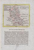
Buckinghamshire Maps
( Page 1 of 4 )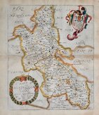
Richard Blome 1673
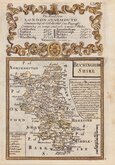
John Seller 1694 [1784]
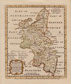
Robert Morden 1695
Robert Morden 1695 [1753]
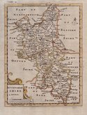
Robert Morden 1701 [c.1708]
Emanuel Bowen 1720
Emanuel Bowen 1758
Emanuel Bowen 1758


19x25 cm
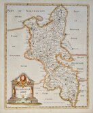
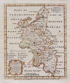
STEEL ENGRAVING WITH VIGNETTE OF ETON COLLEGE
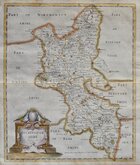
BUCKINGHAMSHIRE
Eng.d by Gray & Son.
Pubd. by Archd. Fullarton & Co. Glasgow.
Steel engraving by Gray & Son first published in Bell's New and Comprehensive Gazetteer in 1833. The text for the gazetteer was largely copied from Lewis' Topographical Dictionary of 1831. In 1839 Lewis obtained an injunction against Bell for plagiarism and the work was withdrawn. Archibald Fullarton, the publisher of Bell's Gazetteer, republished the maps with new text in The Parliamentary Gazetteer from 1840 until 1849. Most of the maps in the series were copied from Sidney Hall's maps published in an earlier topographical dictionary of Great Britain and Ireland by John Gorton published in 1831.
Robert Gray (1771?-1848), Scottish engraver, lithographer and copperplate printer, trading from Glasgow as "Gray & Todd" between 1804 and 1806 and as "Gray & Son" from 1825 to 1848, initially with his son John, and later with his son James who continued the business after Robert Gray's death until at least 1856.
Vignette of Eton. Slight overall toning and a waterstain in the bottom left corner. Two horizontal folds as issued. Neat later hand colour. Early edition without the addition of railways and with Fullarton's Glasgow address in the imprint.
SPECIAL OFFER FRAME AND MOUNT OPTIONS AVAILABLE ON THIS ITEM AT THE CHECKOUT FOR UK DELIVERY.
Quick Links


Berkshire Maps

Road Maps
×