
Bedfordshire Maps
Buckinghamshire Maps
( Page 1 of 4 )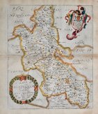
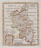
Richard Blome 1673
John Seller 1694 [1784]
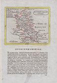
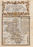
Robert Morden 1695
Robert Morden 1695 [1753]
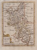
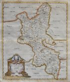
Robert Morden 1701 [c.1708]
Emanuel Bowen 1720
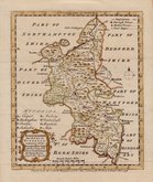
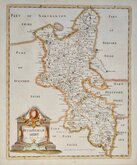
Emanuel Bowen 1758
Emanuel Bowen 1758


54x71 cm
FROM KITCHIN & BOWEN'S LARGE ENGLISH ATLAS.
An ACCURATE MAP of BUCKINGHAMSHIRE Divided into its HUNDREDS Drawn from the best Authorities assisted by the most approved Modern Maps with various Improvements. Illustrated with HISTORICAL EXTRACTS relative to Natural History, Produce, Trade and Manufactures and the present State of the principal Towns By Eman: Bowen Geog.r to His Majesty
Printed for R. Sayer at the Golden Buck in Fleet Street, John Bowles at the Black Horse in Cornhil, and Carington Bowles in S.tPauls Church Yard.
Copper engraving by Emanuel Bowen published in The Large English Atlas from 1760. The work was the first large scale atlas of English counties since the works of Blaeu and Jansson a century earlier and was based on the latest surveys available (most maps at this time were still based on those of Speed and Saxton, their plates being still in use). The maps were a long time in preparation, beginning in 1749 with the county of Sussex and reaching completion of 45 plates in 1760. The engraving work was mostly shared between Thomas Kitchin and Emanuel Bowen. During this time the plates passed through the hands of several publishers and were issued individually and in part works without title. The Large English Atlas was issued by various publishers until c.1794 with very few changes to the maps.
This map of Buckinghamshire, with the imprint of Robert Sayer, John and Carington Bowles is the 5th imprint published from 1765 to 1780.
Additional folds and creasing and small right margin with some repaired tears into the printed margin along this edge. Otherwise the map is a good clean impression in original outline hand colour.
Quick Links


Berkshire Maps

Road Maps
×