
Berkshire Maps
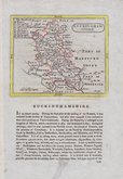
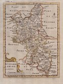
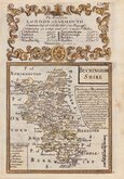
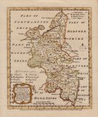
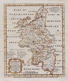
Buckinghamshire Maps
( Page 1 of 4 )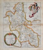
Richard Blome 1673
John Seller 1694 [1784]
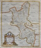
Robert Morden 1695
Robert Morden 1695 [1753]
Robert Morden 1701 [c.1708]
Emanuel Bowen 1720
Emanuel Bowen 1758
Emanuel Bowen 1758


30x44 cm
CASSELL EDITION. FULL HAND COLOUR.
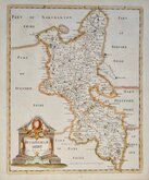
BUCKINGHAMSHIRE
BY B.R.DAVIES FROM THE ORDNANCE SURVEY
LONDON, PUBLISHED BY CASSELL, PETTER & GALPIN, LA BELLE SAUVAGE YARD, LUDGATE HILL, E.C.
Commencing publication in 1859, this series of maps were printed by lithographic transfer from an engraved plate for The Weekly Dispatch Newspaper. The maps were also published as loose sheets and, when the series was complete, in The Dispatch Atlas in 1863. The publishers Cassell Petter and Galpin acquired the plates publishing them as loose sheets from 1864 and in Cassell's Illustrated family paper and Cassell's British Atlas in 1867. By 1869, the firm of G. W. Bacon had acquired the plates and published them in a number of titles for over forty years.
This very clean, fine hand coloured example of the map of Bedfordshire includes statistical, topographical and parliamentary information transferred from type and is from the first issue by Cassell published from 1864 to 1867.
Quick Links


Road Maps

Bedfordshire Maps
×