
Berkshire Prints
Berkshire Maps
( Page 1 of 4 )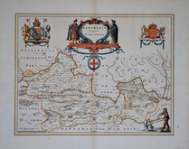
Jan Blaeu 1645
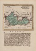
John Seller 1694 [1784]
John Seller 1694 [1784]
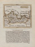
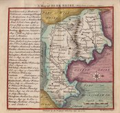
Robert Morden 1695 [1753]
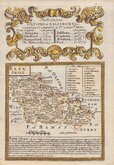
Emanuel Bowen 1720
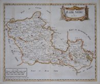
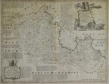
Thomas Badeslade 1742
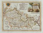
Thomas Kitchin 1751 [1786]
Emanuel Bowen 1756 [1763]


15x15 cm
"BADESLADE & TOMS". NORTH TO THE RIGHT.
A Map of BERKSHIRE. West from London.
T. Badeslade delin. W.H.Toms Sculpt
Publish'd by the Proprietor W H Toms Sept.29.1742.
Published in Chorographia Britanniae, a small and successful pocket atlas, from 1742 to 1749. The maps are engraved by William Henry Toms who claims to be the sole proprietor of the work. It is likely however, that Thomas Badeslade was an early partner responsible for the preparation of the maps, his name appearing on the first title page and on the imprints of the maps. If the claim on the title page that the maps were prepared for George I is to be believed, they were drawn between 1724 and 1727 since the maps are based on those of Herman Moll of 1724.
The first state of the maps appeared with few place names marked but were quickly amended with the addition of more places.
Good hand coloured example from the third state of the plate published between 1742 and 1749. Contemporary manuscript dip pen title verso; Berkshire.
SPECIAL OFFER MOUNT OPTION AVAILABLE AT CHECKOUT FOR UK DELIVERIES
Quick Links

Road Maps

Bedfordshire Maps
×