
Berkshire Prints
Berkshire Maps
( Page 1 of 4 )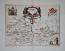
Jan Blaeu 1645
John Seller 1694 [1784]
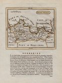
John Seller 1694 [1784]
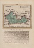
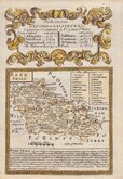
Robert Morden 1695 [1753]
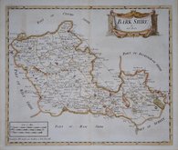
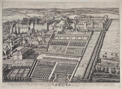
Emanuel Bowen 1720
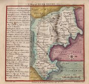
Thomas Badeslade 1742
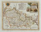
Thomas Kitchin 1751 [1786]
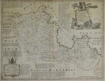
Emanuel Bowen 1756 [1763]


70x54 cm
"LARGE ENGLISH ATLAS"
An ACCURATE MAP of BERKSHIRE Divided into its HUNDREDS Drawn from the best Authorities assisted by Surveys and most approved Maps with various Improvements Illustrated with HISTORICAL EXTRACTS relative to Trade, Manufactures, Natural Produce, & present State of the principal Towns &c. By Emanl. Bowen Geographer to His Majesty
Printed for Carrington Bowles in St Pauls Church Yard, and R. Sayer at the Golden Buck in Fleet Street London 1756
Copper engraving by Emanuel Bowen published as loose sheets from 1756 and in The Large English Atlas from 1760. The work was the first large scale atlas of English counties since the works of Blaeu and Jansson a century earlier and was based on the latest surveys available. The maps were a long time in preparation, the engraving work mostly shared between Emanuel Bowen and Thomas Kitchin, beginning in 1749 with the county of Sussex and reaching completion of 45 plates in 1760. During this time the plates passed through the hands of several publishers and were issued individually and in part works without title. The Large English Atlas was issued by various publishers until c.1794 with few changes to the maps.
This example of the map of Berkshire has the imprint of the publishers Carrington [Carington] Bowles and Robert Sayer dated 1756 and published in atlases from 1763,1763 & 1767.
Original outline hand colour, somewhat faded. There are a number of archival repairs verso to margins and centrefold, which has split to most of it's length and the repair is slightliy misaligned, and a couple of horizontal creases. Occasional browning and spotting.
Despite the fault sit remains a large decorative and detailed map.
Quick Links

Road Maps

Bedfordshire Maps
×