
Bedfordshire Prints
Bedfordshire Maps
( Page 1 of 4 )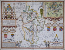
John Speed 1610 [1627]
Michael Drayton 1622
John Seller 1694 [1783]
Robert Morden 1695
Emanuel Bowen 1720
George Rollos 1769
John Cary 1787 [1793]
John Haywood 1788 [1791]


41x33 cm
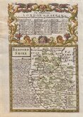
FIRST MAP OF THE COUNTY TO SHOW LONGITUDE BASED ON LONDON.
BEDFORD SHIRE
By Robt. Morden.
Copper engraving produced by Robert Morden for publication in Edmund Gibson's translation of William Camden's Britannia first published by Abel Swalle and Awnsham & John Churchill in 1695. This is the first series of maps to mark longitude in minutes of time (top border) as well as in degrees (bottom border). For most counties longitude is based on the meridian of St. Paul's, London. They were the first folio sized series of county maps to show roads, Morden using the survey and strip road maps of John Ogilby (published in his road book, also entitled Britannia, in 1675). Morden's miniature maps produced on a set of playing cards in 1676, shortly after Ogilb's production, were the first complete set of county maps to include roads. Morden did not use Ogilby's standardisation of measure for the mile at 1760 yards and used the somewhat arbitrary approximation of local variations to include three scales, 'Great', 'Middle' and 'Small' miles on his maps.
The work was republished in 1722, 1730, 1753 and, finally in 1772. The plate was updated for the 1722 edition mostly with changes to place name spellings and was reworked for the 1753 edition due to wear on the plate.
Some occasional light creasing to the paper but it remains a fine example of Bedfordshire from the first issue of 1695 with Stretley duplicated and Segnouls marked with a circle. Fine, thin paper with the watermark P B (Pierre Bernard). Fine later hand colour.
Betty Chambers Printed Maps of Bedfordshire Ref. 18 (i)
Quick Links

Buckinghamshire Maps

Berkshire Maps
×