
Buckinghamshire Maps
Bedfordshire Maps
( Page 1 of 4 )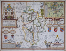
John Speed 1610 [1627]
Michael Drayton 1622
John Seller 1694 [1783]
Robert Morden 1695
Emanuel Bowen 1720
George Rollos 1769
John Cary 1787 [1793]
John Haywood 1788 [1791]


51x39 cm
GEORGE HUMBLE EDITION WITH VARIATION TO TEXT SETTING VERSO.
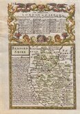
BEDFORD SHIRE AND THE SITUATION OF BEDFORD described with the armes of thos Honorable Fami:lyes that have borne ye titles of Dukes and Earls thereof.
Performed by John Speede, Are to be sold in Popes head alley against the Exchange by George Humbel Cum Privilegio
Jodocus Hondius Celavit Anno Domini 1610
John Speed (1552-1629), born in Cheshire, was a Tailor, becoming a member of the Worshipful Company of Merchant Taylors in 1580. He became interested in History and antiquities and became a member of the Society of Antiquaries and friend of William Camden. In 1611 he published his History of Great Britaine followed by his Theatre of the Empire of Great Britaine the following year. The Theatre was designed as the topographical section to his History and the inclusion of county maps with inset town plans has ensured Speed's name will be remembered. The maps were designed and engraved by Jodocus Hondius in Amsterdam from materials and instructions sent to him by Speed. Speed's main cartographical contribution was the town plans, Speed claiming authorship to those that include a scale of paces "by mine owne travails". The county maps are based on the surveys of Christopher Saxton and John Norden. The inclusion of the internal administrative divisions of the counties was a new innovation by Speed perpetuated in most county maps that followed for the next 300 years. The descriptive text on the back of the maps is taken from Camden and as the text had to be re-set for each issue enables us to date an individual map. On 29th April 1608 George Humble obtained the rights to print and sell the atlas for 21 years but publication did not actually start until 1612 (title page dated 1611). Publication of John Speed's maps continued by various publishers until at least 1770, a publication period of 160 years.
From George Humble's edition published 1627 to 1654.
The textual identification given in The Printed maps and Town Plans of Bedfordshire by Betty Chambers suggests the 1632 edition from the marginal notes but the chapter title is closer to the 1627 edition, not being italic, but the 'C' is not larger and 'XXI' includes a full stop.
Old repairs/strengthening to centrefold verso. Some tape stains at edges. Later hand colour.
Betty Chambers Printed Maps of Bedfordshire ref. 6 (iv)
Quick Links


Berkshire Maps
Bedfordshire Prints
×