
Berkshire Maps
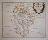
Bedfordshire Maps
( Page 1 of 4 )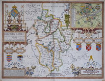
John Speed 1610 [1627]
Michael Drayton 1622
John Seller 1694 [1783]
Robert Morden 1695
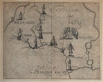
Emanuel Bowen 1720
George Rollos 1769
John Cary 1787 [1793]
John Haywood 1788 [1791]


12x18 cm
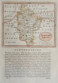
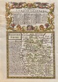
BEDFORD | SHIRE
Map set below a decorative cartouche containing the title and details of the road from London to Oakham commencing at St Albans.
Road map of the first part of the route from Puckeridge to Norwich verso.
Engraved text descriptions below the county map and alongside and below the road map verso.
Engraved by Emanuel Bowen (1693?-1767) and published in the pocket road book Britannia Depicta by Thomas Bowles from 1720 to 1764. The county maps were based on Robert Morden's small series published in The New Description and State of England... from 1701. Text descriptions compiled by John Owen.
Light water damage to top but still a good example in fine hand colour both sides.
Betty Chambers Printed Maps of Bedfordshire Ref. 21
For full description of the road, go to category: Maps > British Isles > RoadMaps > Owen & Bowen.
Quick Links

Bedfordshire Prints

Buckinghamshire Maps
×