
Bedfordshire Prints
Bedfordshire Maps
( Page 1 of 4 )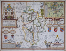
John Speed 1610 [1627]
Michael Drayton 1622
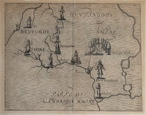
John Seller 1694 [1783]
Robert Morden 1695
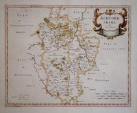
Emanuel Bowen 1720
George Rollos 1769
John Cary 1787 [1793]
John Haywood 1788 [1791]


19x29 cm
ENGRAVER UNCERTAIN BUT BASED ON ROLLOS
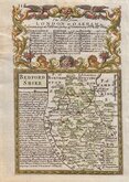
An ACCURATE MAP of BEDFORDSHIRE, Divided into its HUNDREDS, from an Actual Survey
Pubished in England Displayed...London 1769. The majority of county maps for this work were produced by Thomas Read for publication in The Small British Atlas in 1762, some were engraved by Thomas Kitchin for publication in The London Magazine between 1747 and 1763, four were engraved by George Rollos published in The British Magazine in 1762-3, and this map of Bedfordshire copied from the Rollos map in The British Magazine for September 1762.
Although given as a map by George Rollos, the engraver is not certain. The maps are based on the large map by Emanuel Bowen in the Large English Atlas [Bedfordshire published 1750]. As this map includes the hundreds given in a separate key, whereas the Rollos in the British Magazine and the Emanuel Bowen map have the hundreds engraved across the face of the map, Hodson (County Atlases of the British Isles) suggests that it is probable that this map is copied from the Rollos map published in the British Magazine.
George Rollos (1731-1796), was apprenticed to engraver, cartographer and publisher, Thomas Kitchin (1719-1784) who worked with Emanuel Bowen on The Large English Atlas. He seems to have remained a close friend and associate of Thomas Kitchin, following Kitchin's move to St. Albans in 1780 and witnessing his will in that year.
Smallish left margin but a good example in neat later hand colour.
Ref: Chambers Printed Maps of Bedfordshire 43 (ii).
Quick Links

Buckinghamshire Maps

Berkshire Maps
×