
Buckinghamshire Maps
Bedfordshire Maps
( Page 1 of 4 )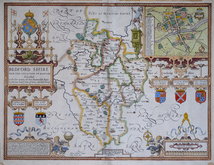
John Speed 1610 [1627]
Michael Drayton 1622
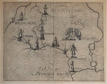
John Seller 1694 [1783]
Robert Morden 1695
Emanuel Bowen 1720
George Rollos 1769
John Cary 1787 [1793]
John Haywood 1788 [1791]


20x27 cm
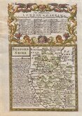
HIGHLY DECORATIVE MAP WITH VIGNETTES AND ARMORIALS.
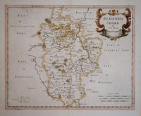
Bedfordshire
This series of decorative steel-plate engraved maps are commonly known by the name Thomas Moule as they were first issued from May 1830 in a series of parts of The English Counties Delineated written by him. The engraving of the plates was shared between James Bingley, W. Schmollinger and John Dower. Confusingly the engravers names were changed after the first issue on a number of plates.
Following the parts issue, the first complete edition of The English Counties Delineated was published by George Virtue in 1837 several editions followed until 1839 and the plates were extensively used thereafter by George Virtue and his son James Sprent Virtue in A Complete and Universal Dictionary of the English Language by the Rev. James Barclay until 1857.
The maps were frequently updated to reflect the rapidly developing railway network.
Final 1852 edition. Later hand colour. Includes vignettes of Dunstable Priory and Woburn Abbey.
Betty Chambers Printed Maps of Bedfordshire ref. 96 (vii)
Quick Links

Bedfordshire Prints

Berkshire Maps
×