
Cambridgeshire Prints
Cambridgeshire Maps
( Page 1 of 4 )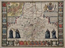
John Speed 1611
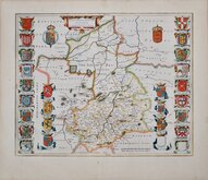
Jan Blaeu 1645
Robert Morden 1696 [1753]
Emanuel Bowen 1720
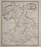
Thomas Read 1743 [1769]

Thomas Kitchin 1750 [1786]
George Bickham 1752
Joseph Ellis 1765


52x38 cm
ONE OF SPEED'S MOST DECORATIVE AND SOUGHT AFTER MAPS. FLANKED BY THE ARMS OF THE COLLEGES.
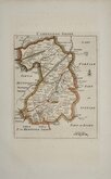
CAMBRIDGSHIRE described with the devision of the hundreds, the Townes situation, with the Armes of the Colleges of that famous Universiti: And also Princes and noble-men as have heer:tofore borne the honor:able tytles & dignities of the Earldome of Cambridg.
Performed by IOHN SPEEDE And are to be solde in popes head alley, by John Sudbury and G. Humbell.
Cum Privilegio.
ANNO. 1610.
John Speed (1552-1629), born in Cheshire, was a Tailor, becoming a member of the Worshipful Company of Merchant Taylors in 1580. He became interested in History and antiquities and became a member of the Society of Antiquaries and friend of William Camden. In 1611 he published his History of Great Britaine followed by his Theatre of the Empire of Great Britaine the following year. The Theatre was designed as the topographical section to his History and the inclusion of county maps with inset town plans has ensured Speed's name will be remembered. The maps were designed and engraved by Jodocus Hondius in Amsterdam from materials and instructions sent to him by Speed. Speed's main cartographical contribution was the town plans, Speed claiming authorship to those that include a scale of paces "by mine owne travails". The county maps are based on the surveys of Christopher Saxton and John Norden. The inclusion of the internal administrative divisions of the counties was a new innovation by Speed perpetuated in most county maps that followed for the next 300 years. The descriptive text on the back of the maps is taken from Camden and as the text had to be re-set for each issue enables us to date an individual map. On 29th April 1608 George Humble obtained the rights to print and sell the atlas for 21 years but publication did not actually start until 1611. Publication of John Speed's maps continued by various publishers until at least 1770, a publication period of 160 years.
Highly decorative map of Cambridgeshire, with the arms of 15 colleges, 11 other armorials, town plan of Cambridge, and four scholars.
Some additional creasing to the paper at the centrefold. 2mm hole below the village of Burrough Green. Trimmed left and right margins with loss to the decorative border. Remargined with decorative border which has been replaced in manuscript.
Despite these faults, the re-margining and replacement border decoration has been done very effectively and with the good hand colouring, which is probably of some age, it remains a very attractive example and a fine, strong impression from the first edition published in 1611 with English text and the woodblock initial letter of William Hall and John Beale verso.
SPECIAL FRAME OFFER FOR UK CUSTOMERS AVAILABLE AT CHECKOUT.
Quick Links

Road Maps

Town Plans
×