
Berkshire Maps
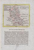
Buckinghamshire Maps
( Page 1 of 4 )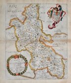
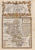
Richard Blome 1673
John Seller 1694 [1784]
Robert Morden 1695
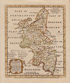
Robert Morden 1695 [1753]
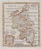
Robert Morden 1701 [c.1708]
Emanuel Bowen 1720
Emanuel Bowen 1758
Emanuel Bowen 1758


26x32 cm
COPIED FROM SPEED
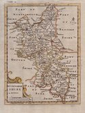
A MAPP OF BUCKINGHAM SHIRE. WITH ITS HUNDREDS BY RIC: BLOME BY HIS MA.ty COMAND.
Dedication and arms to Earl of Bridgewater.
Produced and published by Richard Blome (1635-1705) bookseller, mapseller and publisher, printer to King William III, and cosmographer to Queen Anne, in Britannia: or, A Geographical Description of the Kingdoms of England, Scotland and Ireland...London, Printed by Tho. Rycroft for the Undertaker, Richard Blome. 1673.
This series of maps were produced quickly, following an announcement in the press by John Ogilby, of his intention to produce a new work of county maps, road maps and town plans entitled Britannia. Richard Blome shamelessly used the same title announced by John Ogilby for his work, commencing publication in 1673. Blomes maps are crudely engraved, typical of journeyman work, and mostly copied from those of John Speed, containing no new information. The printing was carried out by Thomas Roycroft, printer to King Charles II.
The publication was probably on sale for four years. There was a re-issue of 1677 made up by John Wright from remaindered sheets.
Toning to paper edges and centrefold but still a good hand coloured example. Large fools-cap watermark.
Quick Links


Road Maps

Bedfordshire Maps
×