
Berkshire Prints
Berkshire Maps
( Page 3 of 4 )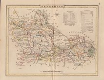
George Cole 1804 [1838]
John Cary 1808 [1809]
Samuel John Neele 1818
Sidney Hall 1820
John Cary 1822
Sidney Hall 1830
Sidney Hall 1830 [1852]
Roger Creighton 1831 [1840]


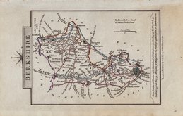
26x20 cm
NEATLY ENGRAVED MAP IN GOOD HAND COLOUR.
BERKSHIRE.
Neele Sculpt. Strand.
Drawn and engraved by Samuel John Neele, this series were based on John Cary's 'quarto' maps of 1793. The early publication of this series is complex with loose issues and parts issues for many counties from about 1812. The first main publication containing the complete set of county maps was The New British Traveller; or, modern panorama of England and Wales...By James Dugdale... published about 1818 by J & J Cundee. The map appeared in three further issues under different titles in 1819 and 1820.
Good later hand colour. Small margins as usual with this series. Later hand colour.
Quick Links

Bedfordshire Maps

Road Maps
×