
Whole of Yorkshire
Yorkshire North Riding
( Page 1 of 3 )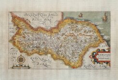
William Hole 1607
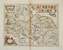
Jan Jansson 1646
Richard Blome North Riding 1673
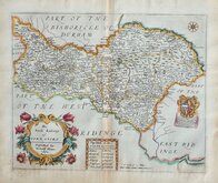
Richard Blome Richmondshire 1673
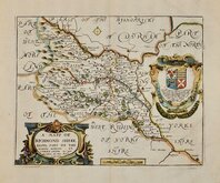
Richard Blome Richmondshire 1673
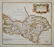
Robert Morden 1695 [1722]
Emanuel Bowen 1720
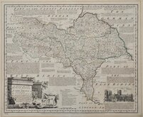
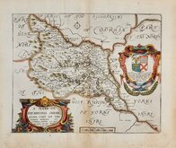
Emanuel Bowen 1763 [1777]


51x42 cm
FROM THE ROYAL ENGLISH ATLAS. SCARCE.
An Accurate Map of the NORTH RIDING of YORK SHIRE, Divided into WAPONTAKES. Drawn from Surveys, & Illustrated with Historical Extracts relative to its Natural produce, Trade and Manufactures, Describing also the Church Livings, Charity Schools &c By Tho.s Bowen. Revised, Corrected & Improved By Eman:Bowen Geog:r to His late Majesty.
London: Printed for Rob.t Sayer, & John Bennett, N.o53 Fleet Street. John Bowles, N.o13 Cornhill. & Carington Bowles, N.o69, S.t Pauls Church Yard, as the Act directs, 1.st June 1777.
Inset view of St. Peter's Cathedral York.
This series of maps, produced for The Royal English Atlas, were a reduction by two thirds of the maps from The Large English Atlas and were first published in 1763 three years after the first complete issue of the Large English Atlas. There were a number of re-issues in the 1770's and 1780's with the final publication in 1828 by R. Martin. It is clear from the scarcity of surviving examples that the work was not a commercial success and the issues were small. As with the maps for the Large English Atlas, the engraving work was shared between Emanuel Bowen and Thomas Kitchin.
Emanuel Bowen (1693?-1767), born in Wales, the son of Owen Bowen, gentleman, of Talley, Carmarthen and his wife Anne. He worked in London from about 1720 to 1767 and was very prolific, engraving plates for many important works including Britannia Depicta, A Complete System of Geography, the London and Universal magazines, Harris' Complete Collection of Voyages, Universal History of the World and many of the maps in The Large English Atlas, The Royal English Atlas and Atlas Anglicanus. He was appointed engraver of maps to George II and Louis XV. His daughter Sarah married his apprentice Thomas Kitchin (1719-1784) who worked with Emanuel Bowen on many works including this, The Royal English Atlas. Emanuel Bowen died aged about 74 "reduced by family extravagances, and almost blind through age" (Gough).
Some overall toning and staining from an old mount outside the plate mark. The reverse is evenly browned. Good margins all round. Original outline hand colour and a strong dark impression on heavy paper from the second edition published from 1778.
A very good example of a scarce map.
Ref. Whitaker Printed Maps of Yorkshire [248]
NOTE:
THIS MAP IS BEING SOLD HERE AS A SINGLE MAP BUT, UNTIL WE SELL AN INDIVIDUAL MAP FROM THE SET, WE HAVE THE FOUR YORKSHIRE MAPS (WEST, EAST & NORTH RIDINGS AND THE WHOLE OF YORKSHIRE) BEING OFFERED TOGETHER IN THE CATEGORY "WHOLE OF YORKSHIRE" AT A DISCOUNTED PRICE.
Quick Links


Yorkshire West Riding

Yorkshire East Riding
×