
Warwickshire Maps
Worcestershire Maps
( Page 1 of 3 )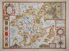
John Speed 1610 [1676]
Richard Blome 1673
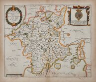
Robert Morden 1695
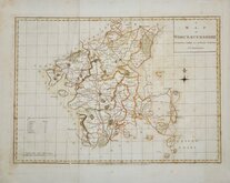
Emanuel Bowen 1720
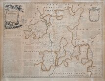
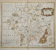
Emanuel Bowen 1756
Thomas Kitchin 1764
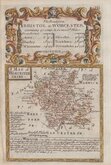
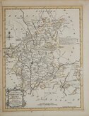
William Fowler 1765
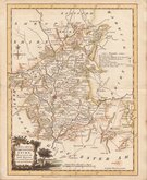
John Haywood 1789


25x20 cm
BASED ON JOHN CARY'S MAP.
WORCESTER S.
Neele Sculpt. Strand. (some loss to this imprint)
Drawn and engraved by Samuel John Neele (1758-1824), this series were based on John Cary's 'quarto' maps of 1793. The early publication is complex with loose issues and parts issues for many counties from about 1812. The first main publication containing the complete set of county maps was The New British Traveller; or, modern panorama of England and Wales...By James Dugdale... published about 1819 by J & J Cundee. The maps appeared in three further issues with the imprint of J. Robins & Co. under different titles; Robins’s Atlas of England and Wales…1819, The New British Traveller…1819, and A topographical and historical description of the county of Hertford…by Mr. E.W.Brayley…1820.
Samuel John Neele was a prolific engraver working from Russell Court from 1781 and 352 Strand from 1785-1824. He traded with his younger brother George Neele as “S.& G. Neele” 1826-1824 and with his son James Neele as “Neele & Son” 1816-1824. .
Small left and bottom margins with stitch holes and glue marks to bottom margin and partial loss of imprint. It remains an attractive and detailed map in fine hand colour.
Quick Links


Staffordshire Maps

Herefordshire Maps
×