
Staffordshire Maps
Worcestershire Maps
( Page 1 of 3 )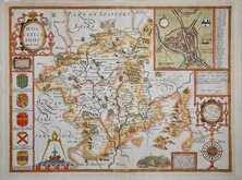
John Speed 1610 [1676]
Richard Blome 1673
Robert Morden 1695
Emanuel Bowen 1720
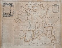
Emanuel Bowen 1756
Thomas Kitchin 1764
William Fowler 1765
John Haywood 1789


70x54 cm
LARGE ENGLISH ATLAS. EARLY TINNEY EDITION.
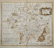
An ACCURATE MAP of the COUNTY of WORCESTER Divided into its HUNDREDS and drawn from the best Authorities Illustrated with Historical Extracts relative to Natural History, Produce, Trade & Manufactures: Showing also amongst various Improvements, |he Rectories, Vicarages, Charity Schools, Religious Houses &c. by Eman: Bowen Geog:r to His Majesty.
Sold by I. Tinney at the Golden Lion & R. Sayer at the Golden Buck in Fleet Street T. Bowles in St Paul's Church Yard and I Bowles & Son at the Black Horse in Cornhill 1756
Copper engraving by Emanuel Bowen (1693?-1767) published in The Large English Atlas from 1760. The work was the first large scale atlas of English counties since the works of Blaeu and Jansson a century earlier and was based on the latest surveys available. The maps were a long time in preparation, beginning in 1749 with the county of Sussex and reaching completion of 45 plates in 1760. During this time the plates passed through the hands of several publishers and were issued individually and in part works without title. The Large English Atlas was issued by various publishers until c.1794 with few changes to the maps.
Original outline hand colour with some 'burning' from the acids used in the original green pigments with a few small holes re-inforced with archival tape verso. Old repair to tear into map at bottom margin into map at Oxfordshire county boundary. Browned overall and a few repaired nicks at paper edges.
An early example with some age related condition issues but still an attractive, detailed large and important map.
Quick Links


Warwickshire Maps

Herefordshire Maps
×