
Cumberland Maps
Westmorland Maps
( Page 1 of 4 )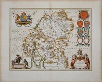
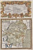
Jan Blaeu 1645
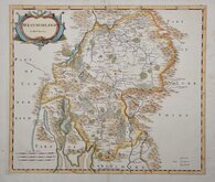
Robert Morden 1695 [1722]
Robert Morden 1695 [1753]
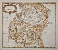
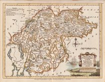
Emanuel Bowen 1720
Emanuel Bowen 1720
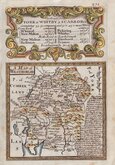
Joseph Ellis 1765 [1773]
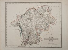
John Cary 1787
Robert Butters 1803


39x33 cm
FINAL COLOUR PRINTED LITHOGRAPHIC ISSUE
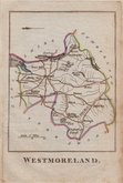
WESTMORELAND
LETTS, SON & Co. LIMITED. LONDON.
LETTS, SON & Co. LIMITED, London Bridge, E.C.
Engraved by J & C Walker, this series of maps were probably based on the map they engraved for C & J Greenwood published in 1834. These maps by the Walker brothers were first issued as folding maps from about 1835 and in an atlas with long title beginning To their Royal Highnesses the Duchess of Kent & the Princess Victoria, this British Atlas, comprising separate maps of every county in England… March 1 1837. The maps were also issued the same year as boxed sets and continued in use under various titles for about 60 years. The most notable editions were the numerous issues for Hobson's Fox Hunting Atlas from 1849 to 1895.
This example of the map of Westmorland is the final issue. Printed by lithographic transfer overprinted with colours, it was published by Letts, Son & Co. in Lett’s Popular County Atlas… in 1887. The lines of graticule across the map with reference numbers in the margin and the printer’s reference X85, which represents the printing date of October 1885, outside border bottom left identify this edition.
Archival tape repairs to centrefold splits top and bottom otherwise good.
Quick Links


Lancashire Maps

Yorkshire Maps
×