
Environs of London
Ward Plans and Parts of London
( Page 3 of 8 )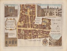
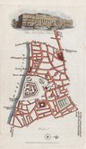
Cheap Ward 1773
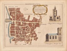
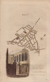
Billingsgate and Bridge Ward 1773
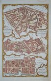
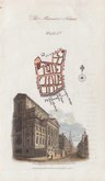
Aldgate Lime Street & Queenhithe Wards 1784
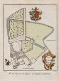
Lambeth Palace 1785
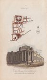
Tower & Minories 1817
Bishopsgate Houndsditch 1817
Lombard Street 1817
The Bank 1817


24x18 cm
For Noorthouck's History of London 1772.
CHEAP WARD | with its Divisions into | PARISHES | according to a | New Survey.
Attributed to Thomas Bowen, this series of plans were copied from those by Benjamin Cole and were first published in a series for The London Magazine by Robert Baldwin from 1766. Robert Baldwin was also the publisher of A New History of London including Westminster and Southwark by John Noorthouck in 1773, and the plates were re-used for this work. Cole's plans, were closely copied from Richard Blome's which were in turn based on the survey of London by John Ogilby and William Morgan (the surveyors were William Leybourn assisted by John Holwell and Gregory King) and produced for Reverend John Strypes illustrated version of John Stow's Survey of London published in 1720. At the time of publication therefore, these plans published in Noorthouck's History, represented London of over 50 years earlier.
Vignettes of Guilhall Chapel, South View of Grocers Hall, South View of S.t Mildreds Church in Poultry, West View of Blackwell Hall. Arms of John Kirkman, (1741-1780) English politician. After the publication of this ward plan, in the General election of September 1780, he was elected as one of the four MPs for the City of London but died on the day the polls closed.
Quick Links


Central London

Middlesex Maps
×