
Central London
Ward Plans and Parts of London
( Page 1 of 8 )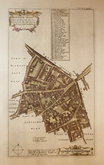
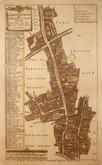
Aldgate Ward 1720
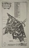
Aldgate Ward 1720
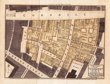
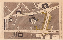
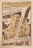
Cornhill Fire 1748
Westminster 1753
Aldersgate Ward. 1755
Aldgate Ward 1756
Bishopsgate Fire 1765
Bishopsgate Fire 1765

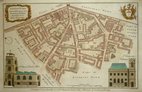
£60 Billingsgate and Bridge Ward
Ref: 6099
Add to
basket
Thanks,Your Product Has Been Added To Basket

24x18 cm
A New and Accurate PLAN of BILLINGSGATE WARD, and BRIDGE WARD WITHIN. Divided into Parishes from a late SURVEY.
Attributed to Thomas Bowen, this series of plans were copied from those by Benjamin Cole and were first published in a series for The London Magazine by Robert Baldwin from 1766. Robert Baldwin was also the publisher of A New History of London including Westminster and Southwark by John Noorthouck in 1773, and the plates were re-used for this work. Cole's plans, were closely copied from Richard Blome's which were in turn based on the survey of London by John Ogilby and William Morgan (the surveyors were William Leybourn assisted by John Holwell and Gregory King) and produced for Reverend John Strypes illustrated version of John Stow's Survey of London published in 1720. At the time of publication therefore, these plans published in Noorthouck's History, represented London of over 50 years earlier.
Vignettes of St. Mary at Hill near Billingsgate and S.t Botolph's in Botolph Lane.
Fine hand coloured example.
Quick Links


Middlesex Maps

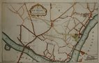
Environs of London
×