
Waterways & Railways
Town Plans
( Page 13 of 13 )


62x46 cm
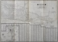
SOUTHEND - ON - SEA.CANVEY ISLAND. RAYLEIGH. SOUTH BENFLEET. ROCHFORD. HOCKLEY.
STREET MASTER BY ATLAS (UK) LTD.
Based on the Ordnance Survey mapping with the permission of the Controller of Her Majesty's Stationery Office.
Printed both sides. Heavy Paper. No date [c.1980]
Good condition
Quick Links

Road Maps

London Maps
×