
Middlesex Maps
Surrey Maps
( Page 4 of 5 )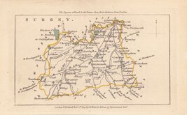
John Walker 1831
John Walker 1831 [c.1832]
Selina Hall 1833 [1852]
Robert Scott 1833 [c.1845]
Christopher & John Greenwood 1834
James Pigot 1839 [1841]
Joshua Archer 1842 [1845]
Benjamin Rees Davies 1863 [1867]


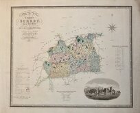
13x8 cm
UNCOMMON MINIATURE MAP. NO SCALE BAR.
SURREY.
London. Published Novr. 1st.. 1831, by B.Nichols & Son, 25 Parliament Strt.
Miniature map engraved by James Cox (fl.1815-1841) from a drawing by John Walker for Benjamin Crosby (1768-1815), the compiler of Crosby's Complete Pocket Gazetteer of England and Wales... 1815.
John Walker is probably John Walker (fl.1813-1873) who was in partnership with his brother Charles (1799?-1872).
The maps later appeared in A compendium of the Ancient and Present state of…(various circuits) 1831-1835, The Family Topographer: being a compendious account of the antient and present state of the counties of England...By Samuel Tymms. John Bowyer Nichols and Son. 1831-1837, and Camden's Britannia Epitomized..1842.
This example, with the publisher's imprint B. Nichols and Son, does not include a scale bar. A scale bar was included in Crosby's Gazetteer but not in The Compendium, Britannia Epitomized, and the first issue of Family Topographer, and was added to most counties in the second issue of the Family Topographer.
An uncommon map in very good hand colour.
Quick Links


Kent Maps

Sussex Maps
×