
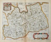
Sussex Maps
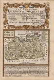
Surrey Maps
( Page 1 of 5 )
Jan Blaeu 1645
Richard Blome 1673
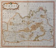
Robert Morden 1695 [1722]

Robert Morden 1695 [1722]
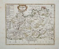
Robert Morden 1701 [c.1708]
Emanuel Bowen 1720
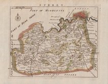
Thomas Read 1744 [1753]
Emanuel Bowen 1756


26x20 cm
NEATLY ENGRAVED MAP IN GOOD HAND COLOUR.
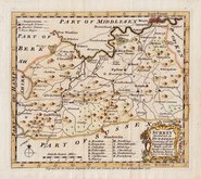
SURRY.
Neele Sculpt. Strand.
Drawn and engraved by Samuel John Neele, this series were based on John Cary's 'quarto' maps of 1793. The early publication of this series is complex with loose issues and parts issues for many counties from about 1812. The first main publication containing the complete set of county maps was The New British Traveller; or, modern panorama of England and Wales...By James Dugdale... published about 1818 by J & J Cundee. The map appeared in three further issues under different titles in 1819 and 1820.
Samuel John Neele (1758-1824) was a prolific engraver working from Russell Court from 1781 and 352 Strand from 1785-1824. He traded with his younger brother George Neele as “S.& G. Neele” 1826-1824 and with his son James Neele as “Neele & Son” 1816-1824.
Good hand colour. Small margin to left edge re-margined in matching paper.
Quick Links


Kent Maps

Middlesex Maps
×