
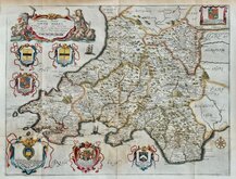
Whole of Wales
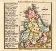
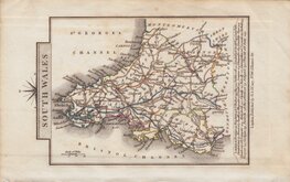
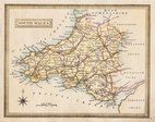
South Wales
( Page 1 of 1 )

20x15 cm
SOUTH WALES
Sixth lithographic transfer from a copper engraved map first published by Henry Teesdale in A new travelling atlas, containing a complete set of county maps.. The whole carefully revised and corrected to the year 1830. The plate and lithographic transfers were amended many times over a period of over 30 years including a complete re-engraving of the map on a slightly larger scale, this edition, with plate number and without imprint, was published by John Heywood in The Travelling Atlas of England and Wales…revised and corrected to the present time. in 1868. The final appearance of the maps were in John Heywood's county atlas of England and Wales in 1882.
Fine hand coloured example.
Quick Links

Welsh Counties
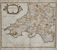
North Wales
×