
Staffordshire Maps
Shropshire Maps
( Page 2 of 3 )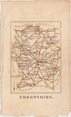
Robert Butters 1804
George Cole 1808
John Cary 1809
Samuel John Neele 1810 [1819]
Sidney Hall 1820 [1834]
John Cary 1822
Roger Creighton 1831 [1840]
Robert Scott 1833 [1845]


9x13 cm
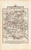
RARE "UPSIDE-DOWN" SERIES.
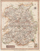
SHROPSHIRE.
The engraver or engravers of this series of maps are unknown and the maps are referenced by the first publisher, Robert Butters, a Fleet Street printer, who issued them in An Atlas of England... London, 1803. They are known as the "upside-down series", the England map and many of the county maps being engraved with North to the bottom of the page. In fact, the county maps are variously orientated with North to the top, left, right or bottom of the page. The work was possibly intended for school use and the odd orientation of the maps was probably to stimulate young minds. This represented Robert Butters' only serious venture into cartography, but unlike the huge success of John Cary's publication The Traveller's Companion, on which these maps were based, Butters’ publication was limited to this single issue. John Hatchard acquired the plates later the same year re-issuing them in a two-volume work The Picture of England 1803, and 1804. Most maps were unchanged in these Hatchard editions but those county maps engraved in landscape format had the titles re-engraved sideways to be consistent with the portrait format of the work. All publications were small and surviving examples are rare.
In keeping with the "upside-down series" Shropshire is engraved with North to the bottom of the page.
Light offsetting from text page at the top of the map and some overall toning but a still good example in original hand colour of a rare map from The Picture of England...by William Green...London, J. Hatchard, 1804.
Quick Links


Herefordshire Maps

Wales Maps
×