
Lincolnshire Maps
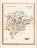
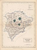
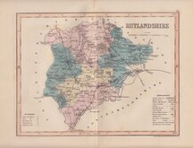
Rutland Maps
( Page 2 of 2 )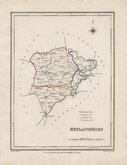
Roger Creighton 1831 [1840]
Robert Scott 1833 [1840]
Selina Hall 1833 [1854]
Joshua Archer 1834
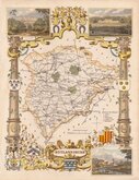
Thomas Moule 1837 [1842]
James Pigot 1839
Joshua Archer 1842 [1858]


17x23 cm
WOODBLOCK ENGRAVED MAP
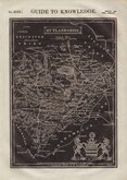
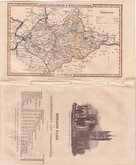
No. XCIX.] GUIDE TO KNOWLEDGE. PRICE ONE PENNY
RUTLANDSHIRE
London, Published for the Proprietors by W.Edwards.12 Ave Maria Lane.
J.Archer.sc.
Printer's imprint verso; Printed by R. Clay, Bread-steet-hill, Cheapside.
Woodblock engraved map by Joshua Archer (1792?-1863) published in weekly parts in The Guide to Knowledge edited by W Pinnock...London: W.Edwards 1833-34.
The unusual printing method whereby the engraved woodblock was inked with a roller without working the ink into the engraved cuts resulting in a white line on a black ground was not suited to to topographical maps and this is the only series of maps to use it.
The guide was re-issued in 1838 and some of the maps appeared in 1844 in (an incomplete) Descriptive county atlas of England and Wales by Groombridge Shepherd & Sutton in a revised state with a decorative border using coloured inks. The final use of the maps was by Thomas Johnson printed more conventionally by lithographic transfer from the Groombridge revised woodblocks in Johnson's Atlas of England in 1847 & 1863. The maps were noticeably out of date by this time following the rapid development of the railway network and were not popular and examples from this publication are rare.
Fine example.
Quick Links


Northamptonshire Maps

Leicestershire Maps
×