
Berkshire Maps
Oxfordshire Maps
( Page 1 of 3 )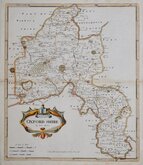
Robert Morden 1695 [1722]
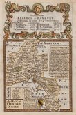
Emanuel Bowen 1720
Thomas Kitchin 1749 [1769]
Emanuel Bowen 1758
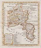
Thomas Kitchin 1763 [1764]
John Cary 1789 [1805]
John Haywood 1791
Benjamin Baker 1793


19x25 cm
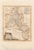
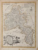
VIGNETTE OF OXFORD FROM THE MEADOWS
OXFORDSHIRE
Pubd. by Archd. Fullarton & Co. Glasgow.
Steel engraving by Robert Scott first published in Bell's New and Comprehensive Gazetteer in 1833. The text for the gazetteer was largely copied from Lewis' Topographical Dictionary of 1831 and in 1839 Lewis obtained an injunction against Bell for plagiarism and the work was withdrawn. Archibald Fullarton, the publisher ofBell's Gazetteer republished the maps with new text in The Parliamentary Gazetteer from 1840 until 1849. The engraving work was shared between Gray & Son, James Neele and Robert Scott with most maps copied from those by Sidney Hall in an earlier topographical dictionary, John Gorton'sTopographical Dictionary of Great Britain and Ireland published in 1831.
The map has the compass rose used by the engraver Robert Scott and the vignette of Oxford from the Meadows bears his imprint. Horizontal folds as isued. A good hand coloured example from the first issue.
SPECIAL OFFER MOUNT OPTION AVAILABLE AT CHECKOUT FOR UK POSTAGE
Quick Links


Buckinghamshire Maps

Town Plans
×