
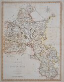
Buckinghamshire Maps
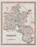
Oxfordshire Maps
( Page 1 of 3 )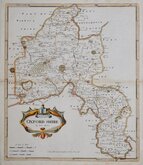
Robert Morden 1695 [1722]
Emanuel Bowen 1720
Thomas Kitchin 1749 [1769]
Emanuel Bowen 1758
Thomas Kitchin 1763 [1764]
John Cary 1789 [1805]
John Haywood 1791
Benjamin Baker 1793


37x43 cm
FIRST MAP TO SHOW LONGITUDE FROM LONDON AND TO INDICATE LOCAL TIME
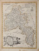
OXFORD SHIRE
By Robt. Morden.
Sold by Abel Swale Awnsham & John Churchill.
Copper engraving produced by Robert Morden for publication in Edmund Gibson's translation of William Camden's Britannia first published by Abel Swalle and Awnsham & John Churchill in 1695.
This is the first series of maps to mark longitude in minutes of time (top border) as well as in degrees (bottom border). For most counties longitude is based on the meridian of St. Paul's, London.
The work was republished in 1722, 1730, 1753 and, finally in 1772. The plate was updated for the 1722 edition mostly with changes to place name spellings and was reworked for the 1753 edition due to wear on the plate.
Robert Morden (fl. 1669-1703) mapmaker, mapseller, globemaker, engraver and publisher, is best known for this series of county maps published in Camden’s Britannia and little is known of his early life. His output was considerable, producing maps and other works in association with many other well known mapmakers and publishers including John Overton, Philip Lea, William Morgan and Christopher Browne. He was a frequent partner of William Berry from the Wakefield area of Yorkshire who was apprenticed to Joseph Moxon, it is most probable that Morden was also apprenticed to Moxon and, given that the Morden name and variants of it are common in Wakefield, he may also come from that area. Morden is recorded as having the polymath Robert Hooke and diarist Samuel Pepys among his customers and associates. He was a member of the Weavers company and churchwarden of his parish church, St. Christopher-le-Stocks, 1679-1680. He and his wife Mary baptised at least seven children at the same church and he was buried with his wife “in ye north ile” on 25th August 1703. Morden did not receive royal appointments granted to less able contemporaries, and he described himself as having “lain latent under the horizon of unknown obscurity and irresistible poverty” and "hoped for better rewards” in the next world.
Very good example from the 1722 edition with the distinctive large watermark of a horse in a circle. Good margins, fine later hand colour.
Quick Links


Berkshire Maps

Town Plans
×