
Berkshire Maps
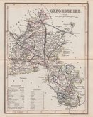
Oxfordshire Maps
( Page 3 of 3 )
Roger Creighton 1831 [1845]
Robert Scott 1833
Joshua Archer 1833
Thomas Moule 1837 [1842]
James Pigot 1839
Joshua Archer 1842 [1846]
Benjamin Rees Davies 1863 [1867]


25x19 cm
"DUKE OF YORK" SERIES
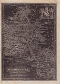
A New MAP of OXFORD SHIRE Drawn from the best Authorities By T.Kitchin Geogr.. Engraver to H.R.H. the Duke of York.
Copper engraving by Thomas Kitchin published in England Illustrated, or, a compendium of natural history, geography, topography… by Robert and James Dodsley in 1764. Thomas Kitchin (1719-1784), one of the foremost engravers of his time, was apprenticed to Emanuel Bowen in 1732 and married his daughter, Sarah, at the end of his apprenticeship in 1739. His works include the map of Scotland by Elphinstone, maps for Geographia Scotiae, the London Magazine and The Large English Atlas working with his father in law Emanuel Bowen.
Robert Dodsley, the publisher of this series, often known as The Duke of York series after the dedication in the title of each map, took his younger brother, James into partnership by 1755 and together published England Illustrated in December 1763 post-dated 1764. The work was re-issued in monthly parts early in 1764. Robert Dodsley died on 23rd September but publication of the monthly parts continued until completion on 1st January 1765. The maps appeared once more in 1765 in an atlas publication without text under the title Kitchen's English Atlas; Or, A Compleat Set of Maps Of All The Counties of England and Wales…By Thomas Kitchen, Geographer to his Royal Highness the Duke of York. London: Printed for J. Dodsley, in Pall-Mall.
Good example in outline hand colour. Some staining at bottom paper edge but with large margins, not affecting plate area.
SPECIAL OFFER MOUNT OPTION AVAILABLE AT CHECKOUT FOR UK POSTAGE
Quick Links


Town Plans

Buckinghamshire Maps
×