
Town Plans
Oxfordshire Maps
( Page 3 of 3 )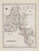
Roger Creighton 1831 [1845]
Robert Scott 1833
Joshua Archer 1833
Thomas Moule 1837 [1842]
James Pigot 1839
Joshua Archer 1842 [1846]
Benjamin Rees Davies 1863 [1867]


18x24 cm
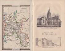
DEPICTING THE COUNTY POOR LAW UNIONS.
OXFORDSHIRE
Drawn by R.Creighton. | ENGRAVED BY J.& C. WALKER.
DRAWN AND ENGRAVED FOR LEWIS' TOPOGRAPHICAL DICTIONARY.
Copper engraving by the firm of J & C Walker from a drawing by Roger Creighton issued in A Topographical dictionary of England… published by Samuel Lewis and Co. from 1831. The work achieved considerable success and was re-issued many times by Lewis until 1849. During this time the maps were amended and updated to include electoral information and the rapidly expanding railway network, with most counties known in at least six different states.
Good clean example with the addition of the poor-law unions outlined in original hand colour issued in 1845.
Quick Links


Berkshire Maps

Buckinghamshire Maps
×