
Berkshire Maps
Oxfordshire Maps
( Page 1 of 3 )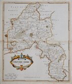
Robert Morden 1695 [1722]
Emanuel Bowen 1720
Thomas Kitchin 1749 [1769]
Emanuel Bowen 1758
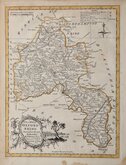
Thomas Kitchin 1763 [1764]
John Cary 1789 [1805]
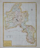
John Haywood 1791
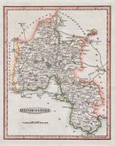
Benjamin Baker 1793


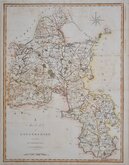
7x12 cm
COLOURFUL MINIATURE MAP
OXFORDSHIRE
Pub. by S. Leigh, 18, Strand. | Sidy. Hall sculpt.
Miniature map engraved by Sidney Hall and first published by Samuel Leigh in Leigh's New Pocket Atlas of England and Wales in 1820. The demand for pocket atlases for the traveller was high during the first half of the 19th century and this little atlas, Samuel Leigh's only cartographic work, was very popular, running to ten editions with publications continued after his death by his widow and then his son until 1839. The plates were then acquired by George Biggs who published them a number of times until 1843.
Good hand coloured example from the first edition of 1820.
Quick Links


Town Plans

Buckinghamshire Maps
×