
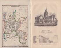
Buckinghamshire Maps
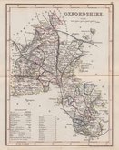
Oxfordshire Maps
( Page 3 of 3 )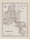
Roger Creighton 1831 [1845]
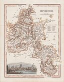
Robert Scott 1833
Joshua Archer 1833
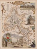
Thomas Moule 1837 [1842]
James Pigot 1839
Joshua Archer 1842 [1846]
Benjamin Rees Davies 1863 [1867]


30x43 cm
HAND COLOURED LITHOGRAPH PRINTED MAP
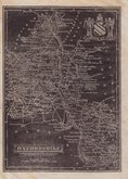
OXFORDSHIRE.
BY B.R.DAVIES. FROM THE ORDNANCE SURVEY.
LONDON, PUBLISHED BY CASSELL, PETTER & GALPIN, LA BELLE SAUVAGE YARD, LUDGATE HILL, E.C.
Commencing publication in 1859, this series of maps were printed by lithographic transfer from an engraved plate for The Weekly Dispatch Newspaper. The maps were also published as loose sheets and, when the series was complete, in The Dispatch Atlas in 1863. The publishers Cassell Petter and Galpin acquired the plates publishing them as loose sheets from 1864 and in Cassell's Illustrated family paper and Cassell's British Atlas in 1867. By 1869, the firm of G. W. Bacon had acquired the plates and published them in a number of titles for over forty years.
This map of Oxfordshire includes statistical, topographical and parliamentary information transferred from type published by Cassell from 1864 to 1867.
A few archival tape repairs verso to chips at right paper edge not affecting the printed area. Fine hand colour
Quick Links


Berkshire Maps

Town Plans
×