
Hertfordshire Maps
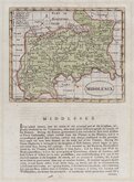
Middlesex Maps
( Page 1 of 5 )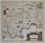
Jan Blaeu 1645

Jan Jansson 1646

Jan Jansson 1646 [1714]
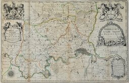
John Seller & John Oliver 1679 [1714]
John Seller 1694 [c.1784]
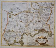
Robert Morden 1695 [1753]
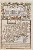
Emanuel Bowen 1720
John Senex 1724


20x16 cm
FINAL ISSUE. NEAT HAND COLOUR.
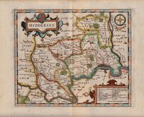
MIDDLESEX
This series of maps were first issued in The English Traveller, published in parts by the Fleet Street printer Thomas Read, from November 1743, with Middlesex appearing on 5th May 1744. Advertisements for the parts issues did not continue after September 1744 but, if the weekly publication was maintained, the work was completed in November 1745. The speed of production would have required the employment of several engravers but none have been identified.
The complete three volume topographical work containing all the maps, The English Traveller…, was first issued in 1746.
On the death or retirement of Thomas Read, the maps passed into the hands of the Huguenot John Rocque (1704?-1762) who published them with revisions to most maps and with a further 19 maps, in The Small British Atlas… from 1753 to 1764. Their final appearance was in England Displayed…London: S.Bladon et.al...1769 and 1770.
With the plate number in the top right margin erased, this map was published in England Displayed...London, 1769.
Some off-setting from the adjacent text page otherwise a good clean example in neat hand colour.
Quick Links


Central London

Environs of London
×