
Central London
Middlesex Maps
( Page 1 of 5 )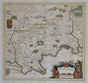
Jan Blaeu 1645

Jan Jansson 1646

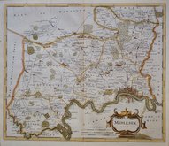
Jan Jansson 1646 [1714]
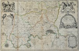
John Seller & John Oliver 1679 [1714]
John Seller 1694 [c.1784]
Robert Morden 1695 [1753]
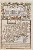
Emanuel Bowen 1720
John Senex 1724


37x24 cm
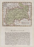
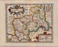
FIRST STEEL ENGRAVED MAP OF THE COUNTY.
MIDDLESEX.
Published by Pigot & Co.24 Basing Lane, London, & Fountain St.Manchester.
Engraved on Steel by Pigot & Son Manchester
James Pigot produced the first National Directory and the maps that accompanied his directories represented a technological advance in printing, being engraved on a steel plate rather than copper. Steel plates were less subject to wear and the development of tools to enable the engraver to work on steel extended the useable life of the plate and allowed the engraver to cut finer lines and show more detail. It is likely that Pigot included a finely engraved and detailed cartouche of a notable local landmark to demonstrate the advantages of this new technology.
This series of maps were first issued in parts from 1826, beginning with the home counties. They appeared in directories shortly after and in Atlas form Pigot & Co,s British Atlas of the counties of England…from c.1830. Production continued under various titles by Pigot and his partner and successor, Slater until 1857.
Includes a vignette of St. Paul’s Cathedral.
Good example in original hand colour from the first edition published in Pigot & Co's British Atlas the First Part comprising London and the home counties issued without title page or text in 1826.
Quick Links


Environs of London

Hertfordshire Maps
×