
Hertfordshire Maps
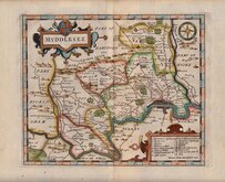
Middlesex Maps
( Page 1 of 5 )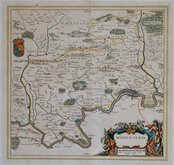
Jan Blaeu 1645

Jan Jansson 1646

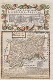
Jan Jansson 1646 [1714]
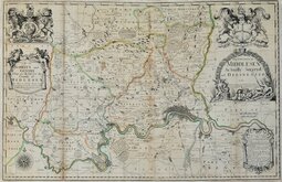
John Seller & John Oliver 1679 [1714]
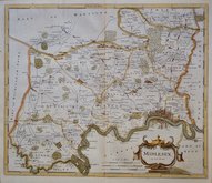
John Seller 1694 [c.1784]
Robert Morden 1695 [1753]
Emanuel Bowen 1720
John Senex 1724


62x60 cm
LARGE MAP WITH FINE VIGNETTES OF WESTMINSTER ABBEY AND ST. PAUL'S CATHEDRAL.
MAP of the COUNTY of MIDDLESEX, from an Actual Survey MADE IN THE YEARS 1819 & 1820. BY C.& I. GREENWOOD.
Published by the Proprietors C. GREENWOOD & Co. 13, Regent Street, Pall Mall, LONDON.
Engraved by J. & J. Neele 352 Strand. CORRECTED TO THE PRESENT PERIOD & PUBLISHED July 4. 1829.
The Greenwoods had planned to produce a set of new surveys of the English counties at an inch to a mile with the claim that they were to be based on new surveys. There is doubt about this claim, the maps appearing to be based on Ordnance survey and other sources but even so, finances were stretched and although an advertisement appeared about 1830 for a full set of English counties at 125 guineas, six counties were not actually completed and their business appears to have ceased trading.
This set of reduced versions of their maps, published in The Atlas of the counties of England, from actual surveys made from the years 1817 to 1833, by C & J Greenwood. in 1834., were issued from the premises of John & Charles Walker, the firm initially employed, among others, by the Greenwoods as engravers.
The maps were engraved on a uniform scale and the small county of Middlesex, although finely engraved with considerable detail, occupied the centre of a large sheet, the surrounding space filled with elaborate title, explanation and large vignettes of Westminster Abbey and St. Paul’s Cathedral.
Light overall toning but still a good example in original hand colour.
Quick Links


Environs of London

Central London
×