
Nottinghamshire Maps
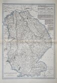
Lincolnshire Maps
( Page 3 of 3 )

44x31 cm
"WEEKLY DISPATCH" CASSELL EDITION
LINCOLNSHIRE
BY JOHN DOWER F.R.G.S.
LONDON, PUBLISHED BY CASSELL, PETTER & GALPIN. LA BELLE SAUVAGE YARD, LUDGATE HILL, E.C.
Lithograph printed map engraved by John James Dower (1825-1901) first published in The Weekly Dispatch August 1858. The maps were also published as loose sheets and, when the series was complete, in The Dispatch Atlas from 1863. The publishers Cassell Petter and Galpin acquired the plates publishing them as loose sheets from 1864 and in Cassell's Illustrated family paper and Cassell's British Atlas in 1867. By 1869, the firm of G. W. Bacon had acquired the plates and published them in a number of titles for over forty years.
John James Dower was the son and successor of engraver John Crane Dower (1791?-1847). He was described as an engraver aged 15 on the 1841 Census. Member of the Royal Geographical Society from 9 Jan 1854. He was recorded as a geographer on the 1871 Census, living with his wife, Mary Ann Augusta, and three children, and on the 1881 Census, as wood engraver, living with his wife, two daughters and two grandchildren. By 1891 he was lodging in Wanstead, now a widower, recorded as a map engraver and draughtsman. He died in Hackney in the first quarter of 1901.
Good hand coloured example from the fourth lithographic transfer, with statistical information in typeset text transferred to the lithographic plate, published in Cassell's British Atlas...London Cassell, Petter & Galpin 1867.
Ref. Carroll Printed Maps of Lincolnshire 120(D)
Quick Links

Rutland Maps

Cambridgeshire Maps
×