
Yorkshire Maps
Lancashire Maps
( Page 2 of 3 )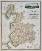
James Franks 1824
John Heywood 1830 [c.1856]
J & C Walker 1831 [1836]
Roger Creighton 1831 [1840]
Robert Scott 1833 [1840]
Thomas Moule 1837 [1842]
Joshua Archer 1842 [1860]
Edward Weller 1863 [1864]


41x51 cm
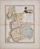
SCARCE. FROM BAINES HISTORY OF LANCASHIRE.
MAP of the County Palatine OF Lancaster. with the LATEST IMPROVEMENTS.
Engraved, 1824, for "BAINES' LANCASHIRE".
T.Wilson, Surveyor. | Engraved by Franks & Johnson.
Published by W.Wales & C.o Castle Street, Liverpool.
Copper engraving by James Henry Franks (fl.1820-1852 d.1857) from a survey by T. Wilson issued with the History of Lancashire by Edward Baines published 1824 & 1836. James Henry Franks traded as "Franks & Johnson" with Frederick John Johnson (fl.1824-1833) from about 1824 to 1833. Both were in Wakefield prison for debt in 1833.
A scarce, large and detailed map, finely engraved with cartouche of Liverpool from Rock Ferry. Folds as usual. Repair to lower half of left margin and decorative border where cropped for binding with loss to the decorative border. Despite these faults it remains a good looking map in fine hand colour.
Quick Links

Cheshire Maps

Westmorland Maps
×