
Yorkshire Maps
Lancashire Maps
( Page 1 of 3 )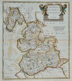
Robert Morden 1695

Emanuel Bowen 1720

Thomas Kitchin 1750 [c.1786]
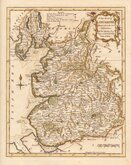
Thomas Kitchin 1763
John Cary 1787 [1808]
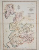
John Cary 1789 [1805]
Henry Cooper 1808 [c.1825]

John Cary 1822


23x36 cm
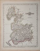
UNCOMMON. PUBLISHED IN BAINES' HISTORY OF LANCASHIRE.
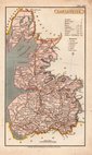
LANCASHIRE
Engrav'd for Baines' History.
Drawn & Engraved by J.& C.Walker.
London, Fisher, Son & Co. 1831.
Drawn and engraved by J & C Walker for Edward Baines' History of Lancashire... published in 1836 by Fisher, Son & Co.
J & C Walker was a partnership between John Walker (1790?-1873) and his brother Charles Walker (1799?-1872) formed about 1897. John Walker was a founder member of the Royal Geographical Society.
Some creases and wrinkles otherwise a good hand coloured example.
Quick Links


Westmorland Maps
Cheshire Maps
×