
John Ogilby
John Senex
( Page 1 of 3 )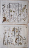
London Bristol
London Banbury
London St Davids
London Harwich
London Towcester
London Lands End
London Newhaven
London Barnstaple


21x15 cm
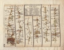
THE ROAD from LONDON to HOLY HEAD. Actually Surveyd.
Plate 21.
First page of the route from London to Holyhead showing London, The Water Rats (The Pinder of Wakefield), New River head, Islington, St. Pancras, Jack Straws Castle, Kentish Town, Holloway, Highgate, Finchley, Whetstone, Totteridge, East Barnet, High Barnet, Hadley, Kitts End, South Mimms, Ridge, London Colney, Napsbury, Sopwell House, St Albans, Redbourn, Flamstead, Markyate, Kensworth, Dunstable, Houghton Regis, Chalk Hill, Sewell, Tilsworth, Tebworth, Hockliffe, Battlesden, Heath and Reach, Kingswod, Little Brickhill, Great Brickhill, Bow Brickhill, Fenny Stratford, Water Eaton, Simpson, Bletchley, Snenley Church End, Loughton, Upper Weald, Middle Weald, Lower Weald, Wolverton, Stony Stratford, Passenham, Potterspury, Alderton, Paulerspury, Cuttle Mill, Heathencote, Towcester.
From the first edition sold by John Senex at the Globe in Salisbury Court, Fleet Street, 1719.
Good example in neat later hand colour.
Quick Links


Owen & Bowen
John Cary
×