
John Cary
John Senex
( Page 1 of 3 )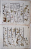
London Bristol
London Banbury
London St Davids
London Harwich
London Towcester
London Lands End
London Newhaven
London Barnstaple


21x16 cm
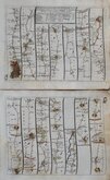
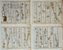
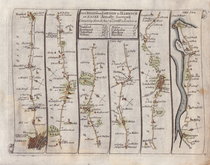
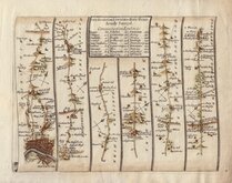
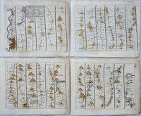
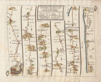
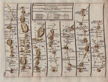
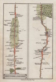
THE ROAD from LONDON to S.t DAVID'S on the Sea Coast in PEMBROKESHIRE Actually Survey'd.
Four maps, plates 14 -17, showing the complete route from London to St. Davids. Plate 14, passing through London, Knightsbridge, Hyde Park, Kensington, Hammersmith, Chiswick, Turnham Green, Brentford, Hounslow, Longford, Colnbrook, Slough, Maidenhead, Henley-on-Thames, Nettlebed, Nuffield, Benson, Dorchester, Clifton Hampden, and Abingdon. Plate 15 shows Abingdon, Shippon, Kingston Bagpuize, Buckland, Faringdon, Buscot, Lechlade on Thames, Fairford, Barnsley, Perrots Brook, Birdlip Hill, Brockworth, Gloucester, Alney Island, Highnam, Huntley, Mitcheldean, Abenhall, Forest of Dean, Monmouth, and Trelleck. Plate 16 shows Devauden, Newchurch, Cats Ash, Christchurch, Newport, Bassaleg, St Mellons, Rumney, Cardiff, Llandough, St Nicholas, Tresimwn, Cowbridge, Penllyn, Corntown, Ewenny, New Inn, Pyle, Aberavon, Baglan, Briton Ferry, Tawe Ferry, Swansea, and Loughor. Plate 17 shows Llanelli, Kidwelly, Ferryside, Llansteffan, Laugherne, Canaston Bridge, Haverfordwest, Pelcomb Bridge, Roch, and St Davids.
Plates 14,15,16 & 17.
Each page has some fingermarking and wear to the right edge with closed tears reaching the printed line on 16,17 & 18. It remains a good set from the first edition sold by John Senex at the Globe in Salisbury Court, Fleet Street, 1719. Good later hand colour. Each page blank verso.
Quick Links

Owen & Bowen

John Ogilby
×