
John Cary
John Ogilby
( Page 1 of 5 )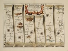
Islip - Bramyard 1675
Bramyard - Aberystwith 1675
Stamford - Newark 1675
Tuxford York 1675
York Durham 1675
London - Dover 1675
Newcastle - Berwick 1675
London - St.Davids Set of 4 Maps 1675


£850 London - St.Davids Set of 4 Maps
Ref: m4346.9
Add to
basket
Thanks,Your Product Has Been Added To Basket

45x33 cm
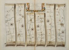
The Road from LONDON to St DAVIDS | in com: Pembroke | By JOHN OGILBY Esqr: | His Ma:ties Cosmographer | …
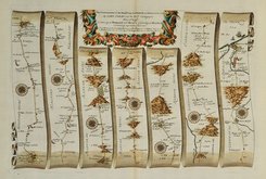
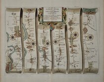
The continuation of the Road from | LONDON to St. DAVIDS. | commencing at ABINGTON Com: Berks, | and extending to MONMOVTH. | By IOHN OGILBY Esq: | His Ma:ties Cosmographer | …
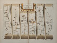
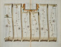
The Continuation of the Road From | LONDON to St. DAVIDS. | commencing at Monmouth & Extending to Burton Ferry- | com: Glamorgan | By Ino. Ogilby Esqr. his Maties. Cosmographer- | …
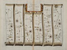
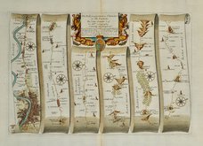
The Continuation of ye Road From | LONDON to St. DAVIDS. co: Pembroke. | commencing at Burton-Ferry & Extending to St. DAVIDS | By JOHN OGILBY Esq.r His Ma.ties Cosmographer ~ |…
From John Ogilby's Britannia.
Set of 4 maps showing the complete route from London to St. Davids showing:
First map: London, Hyde Park, Kensington Chelsea, Hammersmith, Chiswick, Turnham Green, Sutton Court, Ealing, Brentford, Syon House, Isleworth, Hounslow, Heston, Hounslow Heath, Stanwell, Harmondsworth, Longford, Colnbrook, Langley, Slough, Stoke Poges, Farnham Royal, Burnham, Hitcham, Taplow, Maidenhead, Hurley Bottom, Henley on Thames, Nettlebed, Huntercombe End, Nuffield, Ewelme, Benson, Shillingford, Warborough, Dorchester, Long Wittenham, Burcot, Clifton Hampden, Culham, Abingdon.
Second Map: Abingdon, Shippon, Fyfield, Kingston Bagpuize, Longworth, Buckland, Faringdon, Buscot, Lechlade on Thames, Fairford, Barnsley, Elkstone, Brimpsfield, Great Witcombe, Birdlip Hill, Brockworth, Gloucester, Over, Highnam, Highnam Woods, Huntley, Longhope, Mitcheldean, Abenhall, Coleford, Staunton, Monmouth.
Third Map: Monmouth, Lydart, Trelleck, Devauden, Newchurch, Cat's Ash, Christchurch, Newport, Bassaleg, Rumney, Roath, Cardiff, Llandough, St Nicholas, St Hilary, Cowbridge, Llanblethian, Corntown, Ewenny, Cwmafan, Briton Ferry.
Fourth Map: Birton Ferry, Swansea, Loughor, Llanelli, Kidwelly, Ferryside, Llansteffan, Laugharne, Narberth, Robeston Wathen, Canaston Bridge, Llawhaden, Prendergast, Haverfordwest, Pelcomb Bridge, Keeston, Roch, St Davids.
A superb set from the first edition without plate numbers, later numbered 14 to 17. Large paper with fleur de lis watermark and generous margins. Each sheet is in fine condition, the only blemish is a scuff to the paper on the second sheet adjacent to the road between 98 and 99 miles from London below Brockworth, only detectable except under very close scrutiny.
Sold as a set of 4 maps only.
For more information on Ogilby and his work see category heading.
Quick Links
Roads by other Mapmakers

Owen & Bowen
×